
Updated
On this page
Colombia is a country you walk into. Three branches of the Andes fan out across it, and between them sit cloud forests, high-altitude páramo, glacier-topped volcanoes, and jungle that hides ruins older than Machu Picchu. For anyone who likes to earn their views on foot, few countries in the Americas offer this much variety in so little distance. You can wander beneath the world’s tallest palms one week and cross a frost-dusted plateau at 4,000 meters the next.
This guide covers the treks and hikes worth building a trip around, from the multi-day jungle march to the Ciudad Perdida to gentler valley loops in the coffee country. For each one you’ll find what it costs, how to arrange it, and what the walking actually asks of you, along with practical notes on altitude, guides, and the seasons that make the difference between firm trails and deep mud.
The Ciudad Perdida Trek
The Ciudad Perdida, or Lost City, is Colombia’s signature trek and one of the great walks of South America. Hidden deep in the Sierra Nevada de Santa Marta, this terraced settlement was built by the Tayrona people around 800 AD, centuries before the Inca raised Machu Picchu. It sat swallowed by jungle until the 1970s, and there is still no road in. The only way to reach it is on foot, climbing through humid rainforest, crossing rivers, and finishing with a 1,200-step stone staircase up to the terraces.
The standard route is a four-day, three-night trek covering roughly 44 kilometers round trip from the trailhead near the village of El Mababo. Some operators offer the same distance stretched over five days for a gentler pace. It is demanding rather than technical: long, sweaty days on jungle trails, steep in places, with river crossings and simple camp accommodation in shared bunks or hammocks along the way.
Crucially, you cannot walk it independently. The Sierra Nevada is the ancestral home of the Kogui, Wiwa, Arhuaco, and Kankuamo peoples, and access is granted only through a small number of licensed operators who hold permits and work with Indigenous guides. Prices are regulated and identical across every authorized agency, so there is no point shopping around on cost. As of 2026 the fixed rate is COP 1,860,000 (about USD 580) for the four-day trek and COP 2,150,000 (about USD 670) for the five-day version, including transport from Santa Marta, all meals, camp accommodation, and guides. Operators typically ask for a deposit of around 10 percent to confirm, with the balance due in cash.
Book ahead. Spaces fill quickly in the dry months and around holidays, so reserve a week or two in advance in busy periods, and longer if your dates are fixed. One quirk worth planning around: the site closes for most of September into October each year, when the Indigenous communities perform spiritual cleansing rituals and no treks run at all. If you are basing yourself on the coast first, our guide to things to do in Santa Marta covers where to stay and recover on either side of the walk.
Cocora Valley
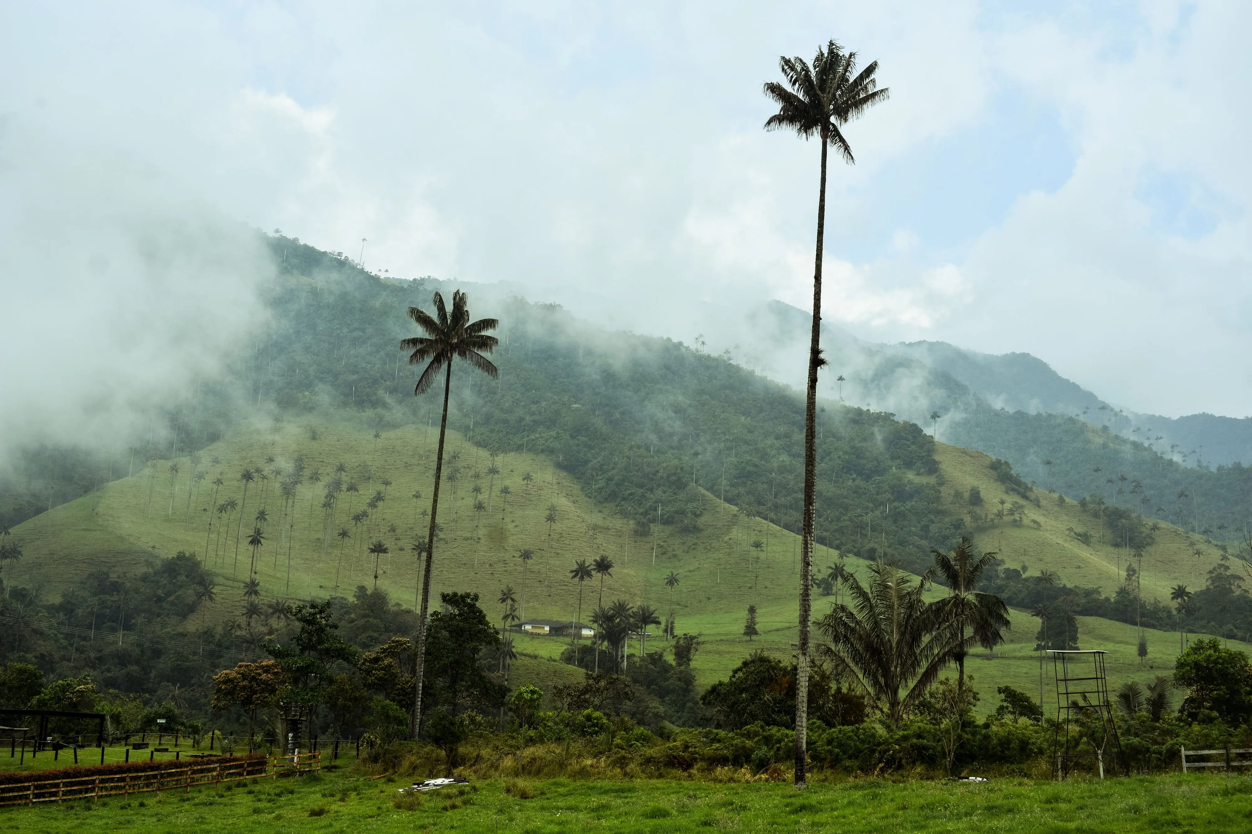
If the Lost City is the country’s toughest classic, the Cocora Valley is its most photographed day hike, and by a wide margin its most accessible. Just outside the town of Salento in the coffee country, the valley is home to the palma de cera (wax palm), Colombia’s national tree and the tallest palm on earth, with the slenderest specimens topping 60 meters. Seeing them scattered across green hillsides, impossibly thin against the cloud, is one of the country’s defining images.
The standard loop runs four to five hours through cloud forest, farmland, and open valley, with a stop at a hummingbird feeding station along the way. It climbs enough to get the heart going but needs no special fitness or gear beyond sturdy shoes and a rain layer. Willys Jeeps rattle out to the trailhead from Salento’s main plaza throughout the morning for a few thousand pesos.
Because it sits at the heart of the Eje Cafetero, Cocora pairs naturally with farm stays, small colonial towns, and tinto by the cup. We cover the walk itself in detail, including the loop direction, timings, and how to beat the crowds, in our Salento and Cocora Valley guide, and the wider region in the Coffee Region hub. It also makes a natural companion to a trip built around Colombia’s coffee culture.
Los Nevados National Park
For high-altitude walking without leaving the coffee region, Los Nevados National Natural Park rises just east of Manizales, Pereira, and Salento. This is Colombia’s Andean roof: a run of snow-dusted volcanoes and glacier remnants surrounded by páramo, that strange, spongy high-altitude moorland studded with the tall, furry frailejón plants found only in the northern Andes.
Access here shifts with volcanic activity, so it pays to check current conditions before committing. Nevado del Ruiz, the park’s most famous peak, has been held at a raised alert level by Colombia’s geological service (Servicio Geológico Colombiano), and entry through the northern Brisas sector has at times been limited to the Valle de las Tumbas viewpoint rather than the higher approaches. Always consult the Servicio Geológico Colombiano’s volcanic status page and your guide before you plan a route.
The most popular objective is Nevado Santa Isabel, long treated as an accessible first taste of high-altitude walking, though its glacier has all but vanished with warming. Day trips typically run from Manizales or Pereira with an early start and a slow, oxygen-thin ascent. A guide is required, and can be arranged in either city or through park-authorized operators. The park charges an entrance fee, with foreign visitors paying more than residents, usually around COP 40,000 (about USD 12). Whatever the peak, this is thin, cold, exposed country, and acclimatization matters as much as fitness.
El Cocuy
Far to the east in Boyacá, the Sierra Nevada del Cocuy is Colombia’s most dramatic high-mountain range: a wall of glaciated peaks, turquoise lakes, and páramo that many walkers rate the finest scenery in the country. It is also the most changeable in terms of access, so it deserves careful planning and up-to-date information.
The celebrated multi-day traverse that once circled the range has been closed for years for environmental and cultural reasons, and El Cocuy is now managed for day hikes only. Several out-and-back routes of varying difficulty climb from the park boundary toward viewpoints, lakes, and the edge of the ice, some of them long and strenuous at altitude. All visitors must register in the towns of El Cocuy or Güicán and hike with an authorized local guide, and the park sets its own rules on group sizes and entry times. Children under a certain age are not permitted, so this is not a trip for young families.
Getting here takes effort. El Cocuy is a long bus ride from Bogotá, and most walkers spend a night or two acclimatizing in town before setting out. That remoteness is exactly why the scenery stays so unspoiled, but it also means regulations can change between seasons. Confirm the current access rules and open routes with the park office before you travel, rather than relying on older trip reports.
Altitude, Guides, and Packing
Colombia’s trekking splits into two very different worlds, and packing for one will not serve the other.
Altitude. Cocora sits at a comfortable elevation, but Los Nevados and El Cocuy push well above 4,000 meters, high enough that altitude sickness is a real consideration regardless of fitness. Give yourself time to acclimatize by spending a night or two at a moderate elevation first, ascend slowly, drink plenty of water, and turn back if headaches, nausea, or dizziness set in rather than pushing through. Bogotá itself sits at 2,640 meters, so a few days in the capital can double as useful preparation.
Guides. For the Ciudad Perdida, Los Nevados, and El Cocuy, a licensed or authorized guide is not optional, it is a condition of entry, and for good reason on remote, high, and culturally sensitive terrain. Book through operators who work directly with local communities. It keeps more of your money in the region and usually buys far better knowledge of the trail, the weather, and the land you are crossing.
Packing. For the Lost City, think heat and humidity: quick-drying clothes, a good insect repellent, a light rain layer, broken-in trail shoes, and a headlamp. For the high Andes, think the opposite: warm layers, a windproof and waterproof shell, gloves, a hat, and strong sun protection, since UV is fierce at altitude even when the air is cold. Sturdy footwear with real grip matters everywhere, as trails turn to mud fast after rain. Carry cash for park fees and camp extras, and treat any river crossing or exposed ridge with the caution it deserves.
When to Trek
Colombia has no single dry season that covers the whole country, so timing depends on where you are walking.
For the Ciudad Perdida and the Caribbean side, the driest and most comfortable windows are roughly December to March and again around July and August, when there is less mud and river crossings are easier. Remember the annual closure that runs through much of September into October, when no treks operate at all.
For the coffee region, including Cocora and the approaches to Los Nevados, the drier months are usually December to March and July to August, though mountain weather is fickle and afternoon showers can arrive in any season. For El Cocuy, the clearest, most stable conditions tend to fall around the turn of the year, with late January and early February often singled out for drier trails and firmer footing.
Wherever you head, mountain weather writes its own rules. Start early to make the most of clear mornings, build a spare day into your plans in case cloud or rain closes in, and let the landscape, not the schedule, set the pace. For the practical basics that apply to any trip into Colombia’s backcountry, see our Colombia safety guide.